dailynewsnblog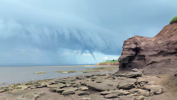

Listen to this article
Estimated 3 minutes
The audio version of this article is generated by AI-based technology. Mispronunciations can occur. We are working with our partners to continually review and improve the results.
Laura MacNeil has been running shoreline tours in the Vernon Bridge area of P.E.I. for six years.
While her tours typically highlight the Island’s fossil sites and ancient history, MacNeil’s group witnessed a very different kind of natural phenomenon on Saturday morning.
“We noticed that there were some really, really dark clouds in the distance, so we figured we had to rush back because we knew we were going to get poured on,” MacNeil said.
As the group turned past a cliff’s edge on their way back to the parking lot, MacNeil spotted a waterspout in the distance. After it dissipated, a second one appeared farther out, which she estimated was about one to two kilometres from the shore.
“I started honestly freaking out, I thought it was so cool,” MacNeil said. “I was just so excited to see such a cool natural phenomenon. It was all just pure excitement.”

The Northern Tornadoes Project, a research group that tracks severe weather across Canada, confirmed the weekend event was a tornado. Because it formed over water, meteorologists classify it as a waterspout.
The group assigned the event an “EF0-Default” rating on the Enhanced Fujita scale, noting on its website that the designation applies because no structural damage was caused.
“We try to detect and assess every tornado across Canada, but we know there are lots of weak tornadoes like this one where you just have to be lucky to catch it,” said Dave Sills, the director of the Northern Tornadoes Project.
“It just survived long enough to throw up some spray over the water, which is a good indication that the winds were fairly strong…. It could have caused damage if it had come on shore, but thankfully it didn’t,” he said.

CBC meteorologist Jay Scotland said there are some differences between conventional tornadoes and the one that formed in P.E.I. on Saturday.
“Unlike conventional tornadoes, waterspouts and landspouts are generally not associated with strong, rotating thunderstorms, so they tend to be weaker and shorter-lived,” Scotland said.
He noted that landspouts can form even on seemingly fair-weather days due to localized atmospheric instability, such as a strong sea breeze or a shifting weather front.
Josh Coles was about halfway between Belfast and Orwell, headed for Charlottetown, when he spotted the tornado on Saturday.
He pulled over to take a closer look and watched for about five minutes as the tornado grew, shrank, and ultimately disappeared.
“Suddenly it was just gone,” he said. “Maybe about five or 10 minutes later … we got a really, really heavy soaking of rain and then right after that we were in a nice, sunny day again.”
Coles said he hasn’t seen that kind of event before, but has heard of it happening.
MacNeil remembers seeing waterspouts off the south shore of P.E.I. about 20 years ago, but they were much farther away from the shore.
Looking back at the photos and videos she took, MacNeil realized the twin funnels were closer than she initially thought.
“This is probably the closest I will ever be to some tornado-like cyclones, which is just absolutely amazing,” she said.
“This is absolutely going to go down as one of the coolest tours I’ve ever done.”