After a week of extreme heat and scattered storms across the country, the unsettled weather pattern continues.
Subscribe to read this story ad-free
Get unlimited access to ad-free articles and exclusive content.
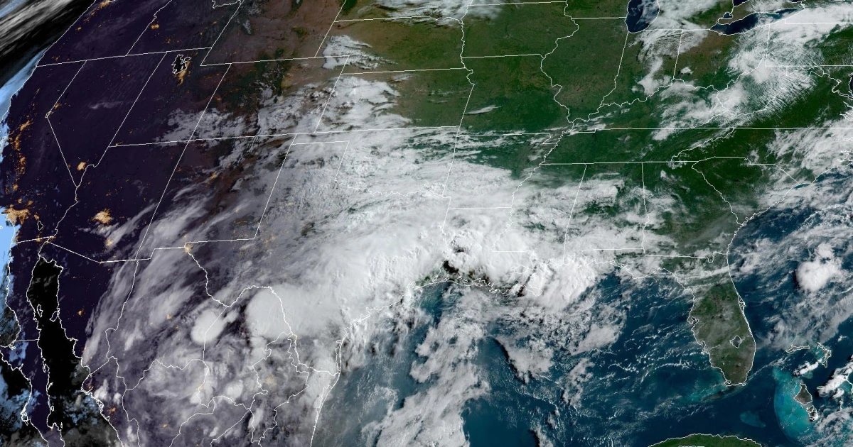
About 20 million people are under flood watches Monday morning, stretching from central and southern Texas to Louisiana and central Mississippi.
Flood watches are in effect through Tuesday, but with tropical downpours and rainfall rates of 2 to 5 inches per hour, there is a strong chance they could be extended in affected areas.
Major cities at risk for heavy rainfall include San Antonio, Austin, Corpus Christi, Houston, Galveston, Beaumont in Texas; Lake Charles and Monroe in Louisiana; and Jackson, Mississippi. These areas face the threat of significant flash flooding, with rainfall totals of 3 to 6 inches possible and isolated amounts exceeding 8 inches. In the Houston metro area, particularly intense flooding is possible.
The heavy rainfall is being fueled by a tropical disturbance — an early-stage, loosely organized system of thunderstorms and clouds that forms in tropical or subtropical waters, according to the National Weather Service.
On Sunday, more than 250 storms were reported across the eastern third of the United States. By Monday morning, roughly 50,000 power outages had been reported due to high winds, including about 26,000 in Ohio and 24,000 in Pennsylvania.
While these areas will see a brief lull in widespread storms, severe weather is expected to return Wednesday in the Midwest and Thursday in the mid-Atlantic.
Roughly 39 million people could be affected by another severe weather outbreak Wednesday, from eastern Kansas to central Ohio, with hazards in this region that may include damaging straight-line winds, large hail and tornadoes. Major cities at risk include Kansas City, Missouri; St. Louis; Chicago; Indianapolis; and Columbus, Ohio.
On Thursday, about 48 million people from eastern Kentucky to Long Island could see severe storms, with cities such as Charleston, West Virginia; Roanoke and Richmond, Virginia; Washington, D.C.; Baltimore; Philadelphia and New York City all in the potential impact zone.
Meanwhile, on the West Coast, extreme heat is building. From northern Washington to California’s Central Valley, high temperatures ranging from the mid-80s to well above 100 degrees Fahrenheit could challenge or break a dozen daily record highs, including in the Portland and Seattle metro areas.