dailynewsnblog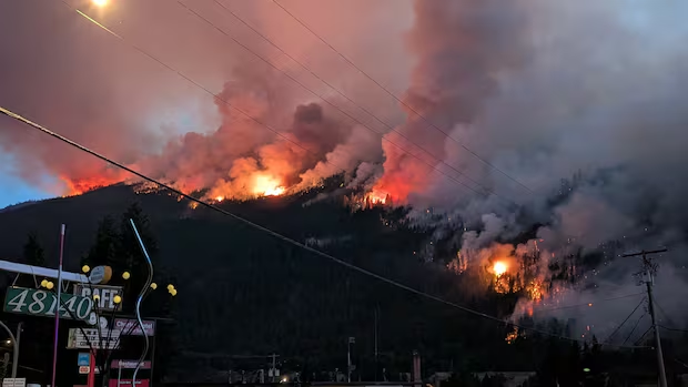
A new wildfire discovered near Boston Bar, B.C., on Tuesday more than quadrupled in size overnight.
The Anderson Creek fire started just south of Boston Bar beside Highway 1, and spread rapidly upslope. It measured at 43.3 square kilometres (4,332 hectares) as of Wednesday evening.
The Anderson Creek fire joins a wildfire complex already burning in the area, on either side of the Fraser River. The Brunswick Creek and Ainslie Creek wildfires together spanned an area that grew to about 234 square kilometres (23,438.3 hectares) as of Wednesday, according to BCWS.
All three are considered “wildfires of note.”

Morgan Blois, BCWS information officer, said the Anderson Creek fire is estimated to be anywhere from 500 to 800 metres away from structures in Boston Bar.
She said the wildfire’s movement upslope has created a lot of energy, which increased the fire behaviour on the Brunswick Creek wildfire.
Residents on edge as fires burn
The Anderson Creek wildfire triggered several evacuation orders Tuesday evening, including properties in and around Hell’s Gate and on Scuzzy Creek forest service road, south of Boston Bar. The Spuzzum First Nation is also under evacuation alert.
The community of Boston Bar has already been on evacuation order for almost a week due to the other fires in the area. The Fraser Valley Regional District (FVRD) sent an urgent alert Tuesday ordering any residents remaining in the community to leave immediately.
Mark Smith, an evacuee who left to Chilliwack, told CBC News he hasn’t slept in weeks.
“You could probably stick me with a fork right now and I don’t think I’d flinch,” he said.

The Lytton Area Wireless Society, The Lytton Area Wireless Society, Lytonnnet, shared footage taken from the west side of Boston Bar, B.C., showing the rapid growth of a wildfire near the community.
Smith lives in a small community just north of Boston Bar called Canyon Alpine. He said after he initially left his home, he returned to the community a few days later to check on some neighbours he hadn’t heard from.
He said his community is a retirement community, and some elderly residents either don’t have a cell phone or don’t know how to use one.
“We’re literally sandwiched, we have fire on both sides to the north and the south,” he said.
“So how do you know a new one has started up? You just don’t, not until that warning has come through.”
FVRD board chair Patricia Ross said the fires were “pretty frightening.” She said residents who were defying evacuation orders “absolutely must leave” immediately.
“This moves so fast, it’s nothing to fool around with,” she said.
She said it has been too unsafe to get more updates regarding structure loss.
Prior to the Anderson Creek wildfire, Ross said there were about 450 properties in the regional district affected by evacuation orders and alerts but she noted that not all the properties had homes on them.

The B.C. Wildfire Service said crews expected “fairly extreme vigorous fire behaviour” Wednesday due to hot and very dry conditions.
Fire behaviour and steep terrain on the Brunswick Creek wildfire made direct attack unsafe for ground crews on Tuesday, the service said. Tactics were being “reassessed” while structure crews engaged in structure defence.
All three fires are suspected to be human-caused, which is how any wildfire not sparked by lightning is categorized.
Highway 1 is closed in both directions between Anderson River Mainline and Jackass Summit for 41.2 kilometres due to the wildfires, according to DriveBC.
Highway 5 should be used as an alternate route, DriveBC said.

More than 80 wildfires across B.C.
There were more than 80 wildfires burning across the province as of Wednesday evening.
Two more wildfires are considered “of note” by the BCWS near Kimberley in southeast B.C.
The Tower Creek 2 wildfire was burning at 2.5 sq. km. (250 hectares) and the Matthew Creek was burning an area of 5.67 sq. km. (567 hectares) as of Wednesday evening.
The wildfire service said earlier Wednesday fire activity was subdued overnight on both wildfires but it expects fire activity to pick up in the afternoon during the warmest and driest part of the day.
The City of Kimberley and Regional District of East Kootenay have issued evacuation alerts due to the wildfires.

The Lytton Area Wireless Society, Lytonnnet, shared 17 days of timelapse footage of the Brunswick Creek fire near North Bend, B.C., viewed from their tower over Boston Bar.
In B.C.’s north, a swath of land covering several lakes and recreation sites along Batnuni Road, located about 150 km southwest of Prince George, was put under evacuation order on Wednesday evening.
It is unclear if there are any properties in the evacuation order area.
The Fiftynine Creek wildfire, burning in B.C.’s Cariboo region, prompted an evacuation alert for the village of Clinton on Wednesday afternoon.
The Thompson Nicola Regional District has also expanded an evacuation order and an evacuation alert for the Bonaparte Plateau area.
Wildfire smoke has prompted Environment Canada to issue an air quality warning for the entire eastern half of the province.
It says people should stay indoors with cleaner air as much as possible and avoid strenuous activity outside.