dailynewsnblog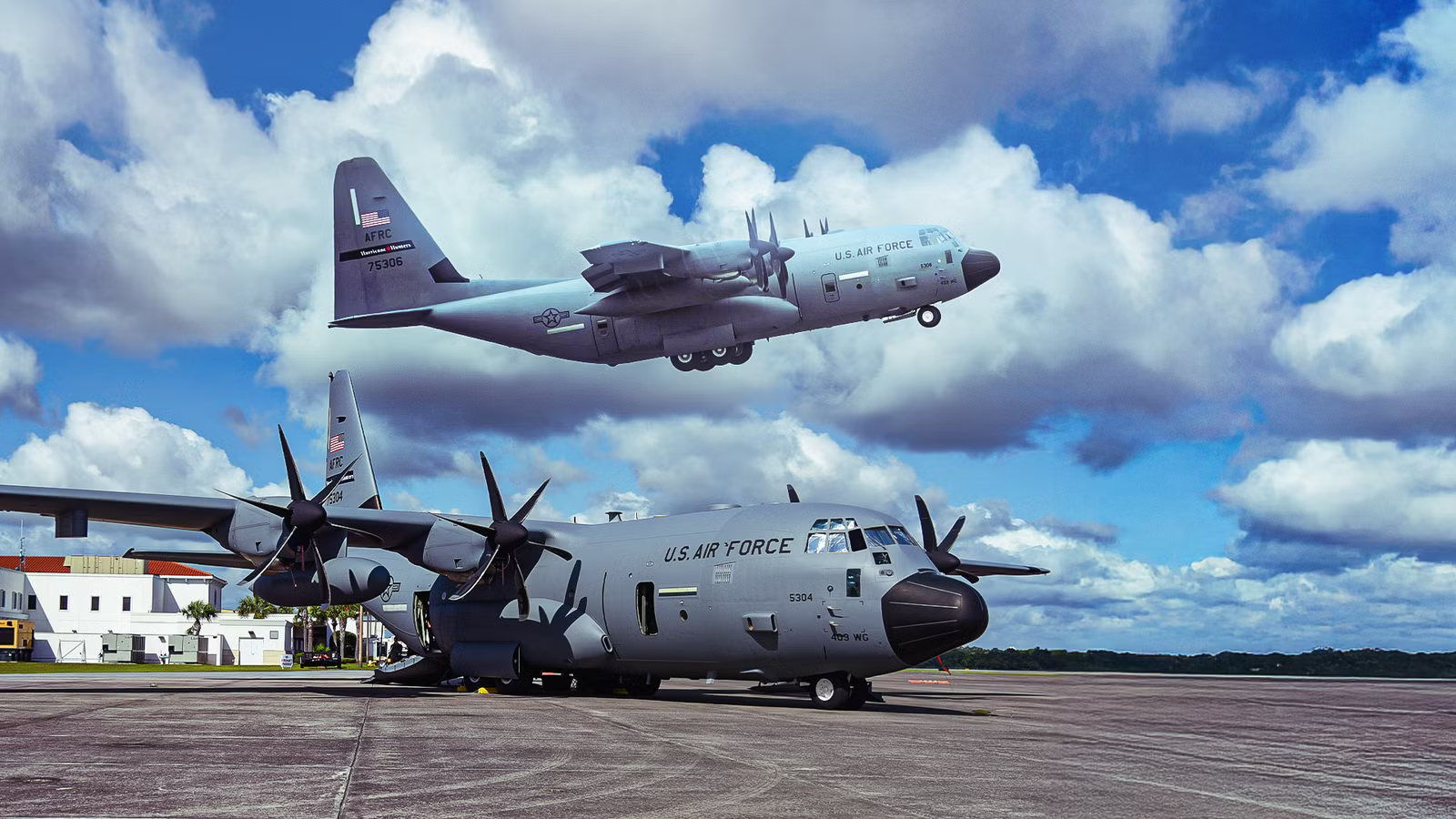
On August 10, three Lockheed Martin WC-130J Super Hercules aircraft departed Keesler Air Force Base (BIX) in Biloxi, Mississippi, and flew west toward Hawaii to intercept Tropical Storm Lala in the Central Pacific. The aircraft, flying under call signs TEAL81, TEAL82, and TEAL83, were operated by the 53rd Weather Reconnaissance Squadron, the Air Force Reserve unit known as the Hurricane Hunters and the only Department of Defense organization still flying into tropical storms and hurricanes. Over the next four days, the crews flew repeated passes through Lala at 10,000 feet (3,048 meters), releasing dropsondes that measured wind speed, pressure, temperature, and humidity from flight altitude to the ocean surface. It was the squadron’s third Hawaii deployment of 2026.
The flights were visible in real time on Simple Flying’s live flight tracker under their TEAL call signs, producing the distinctive cross-shaped flight patterns that distinguish a hurricane reconnaissance mission from every other type of air traffic. Anyone watching the tracker during the deployment could follow the aircraft from Biloxi to Hawaii, into the storm, and back. The Hurricane Hunters have been flying into tropical cyclones since 1944 using instrumented aircraft that collect data satellites cannot replicate. The data they gather improves National Hurricane Center forecast accuracy by up to 20%.
You Can Track The Hurricane Hunters On The Flight Tracker

The WC-130J Super Hercules aircraft flown by the 53rd Weather Reconnaissance Squadron carry ADS-B transponders and fly under TEAL call signs that are visible on flight tracking platforms. On August 10, 2026, three aircraft departed Keesler Air Force Base (BIX) in Biloxi, Mississippi, heading west toward Hawaii to track Tropical Storm Lala in the Central Pacific. The aircraft flew as TEAL81 (serial 96-5302), TEAL82 (serial 97-5305), and TEAL83 (serial 98-5308). Anyone watching Simple Flying’s Live Flight Tracker during the deployment could follow the aircraft from Biloxi across the continental United States, over the Pacific, and into the storm.
What makes the Hurricane Hunters immediately identifiable on the tracker is their flight path once they reach the storm. A commercial aircraft flies a straight line from departure to destination. A WC-130J flying a hurricane reconnaissance mission flies a pattern that looks nothing like normal air traffic. The aircraft enters the storm, flies through the center, exits the other side, turns around, and flies back through again on a different heading. The repeated passes through the eye produce a distinctive cross pattern on the tracking map, with multiple track lines intersecting at the storm’s center. The aircraft operates at approximately 10,000 feet (3,048 meters), far below the altitude where commercial traffic cruises, which makes the flight path stand out further against the surrounding traffic.
The TEAL call signs are the key to finding them. During hurricane season, which runs from June 1 through November 30 in the Atlantic and Central Pacific, viewers can search for TEAL flights on the tracker whenever a tropical system is active. The call signs appear in the tracker’s search function alongside the aircraft’s position, altitude, ground speed, and heading. During the Lala deployment, the three TEAL flights were visible on the tracker from the moment they departed Biloxi through their storm passes near Hawaii and their return to the mainland after the mission concluded on August 14. The tracker turns a military weather reconnaissance mission that most people never see into something anyone can follow in real time from a phone or a computer.
What The 53rd Weather Reconnaissance Squadron Actually Does

The 53rd Weather Reconnaissance Squadron is the only Department of Defense organization still flying weather reconnaissance missions into tropical storms and hurricanes. The mission dates to 1944, when a pilot flew a single-engine trainer into a hurricane on a dare and demonstrated that manned aircraft could penetrate and survive tropical cyclones. The military formalized the mission shortly afterward, and the squadron has been flying into storms continuously since then, with brief interruptions for organizational changes. The unit is part of the 403rd Wing, Air Force Reserve Command, based at Keesler Air Force Base in Biloxi, Mississippi, approximately 80 miles (129 km) east of New Orleans on the Gulf Coast.
The squadron operates a fleet of 10 Lockheed Martin WC-130J Super Hercules aircraft, a militarized variant of the C-130J transport modified with weather instrumentation, dropsonde deployment systems, and reinforced airframes designed for sustained flight in severe turbulence. Twenty flight crews staff the squadron. Each crew consists of five members: an aircraft commander, a co-pilot, a navigator, an aerial reconnaissance weather officer, and a loadmaster. The aerial reconnaissance weather officer is the mission specialist who interprets the weather data collected during each pass through the storm and communicates findings to the National Hurricane Center in Miami. The loadmaster manages the dropsonde inventory and deployment during the flight.
The squadron flies two categories of missions. Hurricane reconnaissance missions fly at approximately 10,000 feet (3,048 meters) directly through tropical storms and hurricanes in the Atlantic, Caribbean, Gulf of Mexico, and Central Pacific. Atmospheric river reconnaissance missions, which the squadron also flies during winter months, operate at approximately 30,000 feet (9,144 meters) along predetermined paths over the Pacific to collect data on moisture-laden atmospheric rivers approaching the US West Coast. Maj. Sarah Olson, a pilot with the squadron, noted that the two mission types require different flight profiles, different altitudes, and different crew techniques, but both serve the same purpose: collecting atmospheric data that ground-based and satellite instruments cannot measure with the same precision or resolution.
How The Crew Flies Into A Storm At 10,000 Feet

The WC-130J enters a tropical storm or hurricane at approximately 10,000 feet (3,048 meters), flying directly into the wind field at an altitude where the storm’s structure is most relevant to forecasters trying to determine its intensity and track. The aircraft does not circle the storm from a safe distance or observe it from above. It flies through the eyewall, the most turbulent part of the storm where wind speeds are highest, into the eye, through the opposite eyewall, and out the other side. The crew then turns the aircraft around and flies back through on a perpendicular heading, creating a cross-shaped pattern across the storm’s center. Multiple passes are made during each mission to build a complete picture of the storm’s wind field and pressure structure.
During each pass, the crew releases dropsondes, cylindrical instruments approximately the size of a cardboard shipping tube that are ejected from a pneumatic tube-launch system mounted to the cargo bay floor. Each dropsonde descends through the storm on a small parachute, measuring wind speed, barometric pressure, temperature, and humidity at every altitude from 10,000 feet (3,048 meters) to the ocean surface. The data transmits in real time to the aircraft’s aerial reconnaissance weather officer, who interprets the readings and relays them to the National Hurricane Center (NHC) in Miami. The measurements provide a vertical profile of the storm’s atmosphere that satellites cannot replicate, because satellite instruments measure the top of the cloud canopy and infer conditions below it, while the dropsonde measures conditions directly at every level from flight altitude to the surface.
The data the dropsondes collect improves NHC forecast accuracy by as much as 20%, according to the hurricane center’s own assessment. The improvement is largest in the Central Pacific, where Tropical Storm Lala formed in an area the NHC describes as data-sparse. Over the open ocean far from land-based weather stations and away from the dense network of commercial aircraft that provide atmospheric data along busy airline corridors, the WC-130J and its dropsondes are the only source of direct atmospheric measurements inside the storm.
Satellite imagery can show where the storm is and estimate how strong it looks. The Hurricane Hunters measure what is actually happening inside it. Maj. Olson described the process during the Lala deployment: when the aircraft enters the storm, the crew determines the center by analyzing the winds, then makes additional passes to determine how the center is moving. That ground truth is what the forecast models need to produce the track and intensity predictions that drive evacuation decisions and emergency preparations hundreds of miles away.
The Lala Deployment: Three Aircraft, Three Days, One Storm

Three WC-130Js departed Keesler Air Force Base on August 10, 2026, flying west across the United States and over the Pacific to Hawaii. The deployment was the squadron’s third to Hawaii in 2026 alone, a pace that reflects an active Central Pacific storm season. Maj. Olson noted that the squadron had already deployed to Hawaii twice before Lala and was prepared to return if the National Hurricane Center requested additional missions later in the season.
The squadron operated from the Big Island near Kona, positioning the aircraft close to the storm’s projected path. Tropical Storm Lala was moving through a stretch of open Pacific that is thousands of miles from the nearest continental weather station and outside the normal flight paths of commercial aircraft that provide supplemental weather data along their routes. The WC-130J crews began flying into Lala on August 12, 2026. On their first pass that day, the crew was greeted by a rainbow as they descended into the storm, a detail captured in photographs released by the US Air Force. The flights continued through August 14, when the squadron made its final pass through the storm. Over those three days, the crews flew multiple missions collecting dropsonde data, wind measurements, and pressure readings that the NHC used to refine its track and intensity forecasts for a storm that was strengthening from a tropical storm into a Category 1 hurricane as it approached the Hawaiian Islands.
After the final mission on August 14, the crews returned to California before continuing east to Biloxi. Olson described Lala as her first storm deployment of the year and noted that the squadron remains ready to redeploy if additional storms threaten. The Hurricane Hunters’ mission tempo during peak season means the aircraft and crews can be tasked with back-to-back deployments with minimal downtime between storms. Three Hawaii deployments in a single season is unusual but not unprecedented. The Central Pacific basin typically produces fewer named storms than the Atlantic, but when systems do develop in the region, the data-sparse environment makes the WC-130J missions more operationally critical than in the Atlantic, where a denser network of buoys, coastal stations, and commercial aircraft supplement the hurricane reconnaissance data.
Why Flying Into A Hurricane Is Safer Than It Sounds

The public perception of Hurricane Hunter missions involves an aircraft being tossed around inside a Category 5 hurricane at the edge of structural failure. The reality is more controlled than that. The WC-130J is a modified C-130J Super Hercules, a four-engine turboprop cargo aircraft with a reinforced airframe designed to withstand the turbulence encountered inside tropical cyclones. The wings, fuselage, and control surfaces are strengthened beyond what a standard C-130J requires, and the aircraft carries specialized weather instrumentation mounted in the cargo bay that takes up two pallet positions. The WC-130J is not a fragile research aircraft improvising its way through a storm. It is a military cargo platform engineered for the mission.
The crew is trained specifically for storm penetration. Pilots assigned to the 53rd Weather Reconnaissance Squadron do not fly into hurricanes on their first mission. They become storm-certified only after flying through the inner eyewalls of hurricanes under the supervision of experienced aircraft commanders. Capt. Ashley Kosturock, a 53rd WRS pilot, described the workload during severe turbulence: “Sometimes turbulence can be so severe that the autopilot disconnects, and one pilot may have to hand-fly the airplane while the other manages the throttles. At that point, the two pilots must work together to make sure they don’t overspeed or stall the airplane.” Retired Lt. Col. Dave Borsi, who flew approximately 75 hurricane missions, acknowledged that there are times when “the turbulence is so extreme that it isn’t possible to focus on the instrument panel.” The training prepares crews for those moments so the response is procedural rather than reactive.
The squadron maintains safety margins that include aborting a mission if conditions exceed what the aircraft and crew can safely handle. During Hurricane Melissa in October 2025, a WC-130J crew flying as TEAL75 encountered turbulence “stronger than normal” while attempting to penetrate the eye of the Category 5 storm. The crew aborted the mission and returned to base for an aircraft inspection before the next flight. The decision to turn around is built into the mission protocols. The squadron does not treat every storm penetration as an obligation to complete regardless of conditions. If the turbulence exceeds the crew’s assessment of what the aircraft can safely handle, they exit the storm, inspect the aircraft, and return when conditions or approach angles improve. The mission has been flown continuously since 1944, and the squadron’s safety record across eight decades of flying into the most powerful storms on the planet reflects the combination of a purpose-built aircraft, a trained crew, and procedures that prioritize safety margins over data collection when the two conflict.