dailynewsnblog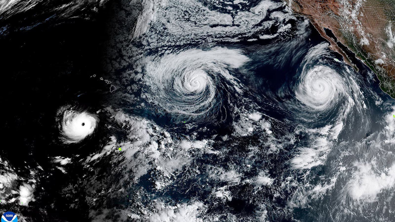
Hawaii and Southern California are facing high surf impacts this weekend as multiple tropical systems churn across the Pacific Ocean.
Hurricane Lowell and Tropical Storm Karina are not forecasted to make landfall but are bringing high surf impacts to the Hawaiian Islands over the holiday weekend.
Farther east, Hurricane Marie, which is also not forecast to make landfall, is fueling rough surf and dangerous rip currents along the coast of Southern California.
Tropical activity in the central and eastern Pacific remains very active due to El Nino’s effects.

What to know about Hurricane Lowell
As of Saturday afternoon, Lowell remained a Category 4 hurricane, with maximum sustained winds of 145 mph. It was moving to the west-northwest of 7 mph, and the center was located more than 600 miles south-southwest of Honolulu.
Lowell is forecast to make a turn to the north over the next 24 hours and will pass west of the main Hawaiian Islands late Monday into Tuesday morning.
Little change in strength is forecast over the next 24 hours before a gradually weakening trends commences through Monday as it moves north.
Lowell could still be at major hurricane strength as it passes west of the islands, before a more substantial weakening trend unfolds by early Tuesday.

Lowell is already bringing high surf to the south and southeast facing shores of the islands. A High Surf Advisory is in effect for waves up to 12 feet along these shorelines.
Some of the outer bands could impact the western Hawaiian Islands early next week, depending on its track. A period of strong, gusty winds could also impact Kauai County on Monday and Monday night.
While Lowell will pass west of the main Hawaiian Islands, it will push a copious amount of tropical moisture north, fueling periods of heavy rain beginning late Sunday.
Rounds of rain, with locally heavy downpours, will persist through early next week and could produce areas of flash flooding and mudslides, especially in areas with steep terrain.

Currently, the biggest rainfall totals are forecast to occur on Kauai, due to its closer proximity to Lowell and on the Big Island due to its very large mountains. On these islands, four to six inches of rain are possible, with isolated amounts up to 10 inches in the higher elevations.
Lower rainfall totals are expected on Maui and Oahu, with generally one to four inches forecast through early next week.
The highest amounts, which could locally exceed four inches, will also be across mountainous areas. Widespread flash flooding and significant rain impacts are not currently expected, since these totals will add up over several days.
What to know about Tropical Storm Karina
Meanwhile, Karina has now weakened to a tropical storm with maximum sustained winds of 65 mph. The weakening trend will continue over the weekend, and the storm will likely dissipate by late Sunday night.
Karina is currently churning more than 750 miles from the Big Island and will remain far out to sea. However, it will bring high surf impacts to Hawaii’s east-facing shores as swells from the storm move towards the islands.
For east-facing shores, a High Surf Advisory is in effect through Sunday due to the rough surf and big waves.

What to know about Hurricane Marie
Finally, Hurricane Marie continues to churn in the eastern Pacific, roughly 700 miles from the southern tip of Baja California.
Marie is forecast to weaken over the next few days as it continues to move northwestward over the eastern Pacific, far away from any land. It will likely weaken to a tropical storm by Sunday night and dissipate early next week.
Swells generated by Marie will continue to affect portions of the coast of southwest Mexico, the Baja California Peninsula and southern California over the long holiday weekend, bringing rough surf and an elevated risk of rip currents.
There is a “high risk” of dangerous and potentially life-threatening rip currents up and down the southern California coast through the Labor Day holiday on Monday.