dailynewsnblog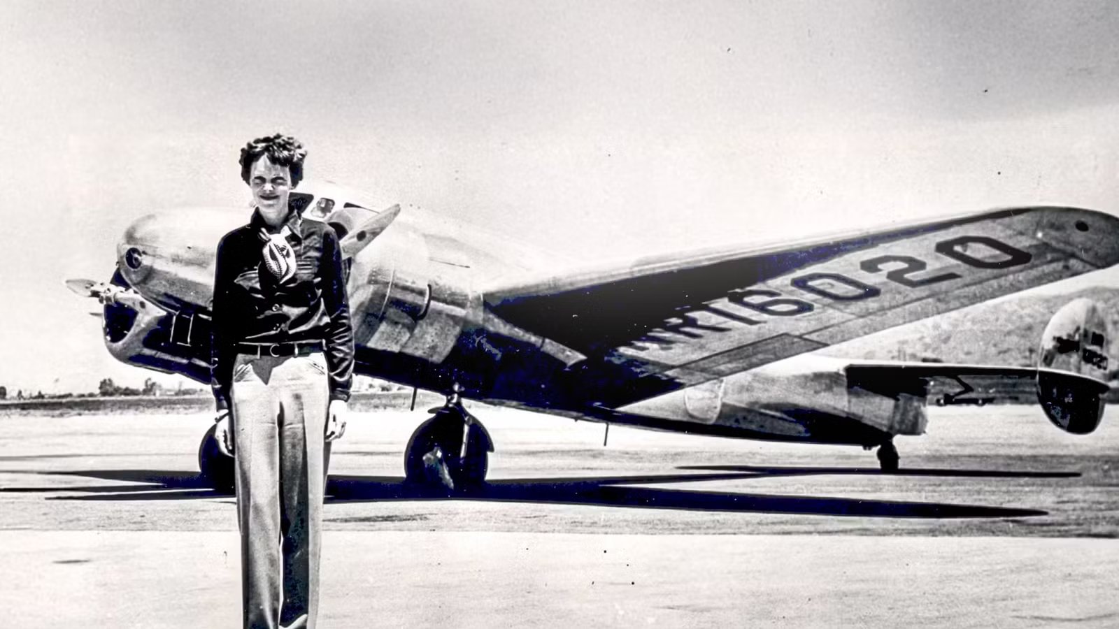
On July 2, 1937, Amelia Earhart and navigator Fred Noonan took off from Lae, New Guinea, embarking on the most perilous leg of their round-the-world flight attempt: a 2,556-mile (4,113 km) transoceanic journey across the Pacific Ocean toward Howland Island. Stationed near the tiny coral outcrop, the United States Coast Guard cutter Itasca was a vital radio contact point, attempting to guide the twin-engine Lockheed Electra 10E toward the remote airfield. As the aircraft approached the island, communication became far more difficult.
According to the National Archives, which preserves the original radio log from the Itasca, the vessel recorded its final confirmed transmission from Earhart at approximately 8:43 a.m. The message carried an unmistakable sense of urgency, with Earhart reporting, “we are on the line 157 337,” before noting that the aircraft was running north and south along that sun line of position as fuel reserves dwindled. Following that brief transmission, all subsequent attempts by the Itasca to re-establish contact failed, launching an unprecedented search effort by the United States Navy and Coast Guard and cementing those words as one of the most haunting final statements in aviation history.
Problems Existed From The Start

Taking off from Lae was already filled with operational hazards before the aircraft even reached cruise altitude. The modified Lockheed Electra 10E was weighted down to its absolute limit with roughly 1,150 gallons (4,353 liters) of fuel, which meant Earhart had to use every foot of the unpaved coastal strip. Sinking low over the ocean at the end of the runway to gather airspeed, the twin-engine plane began its long climb, locking the crew into an 18-hour transoceanic leg with no option for a mid-route diversion.
Targeting a landmass measuring just 1.5 miles by 0.5 miles (2.4 km by 0.8 km) could only be possible with unrelenting precision from navigator Fred Noonan. Relying on dead reckoning and celestial fixes taken with a bubble octant, Noonan had to continuously calculate wind drift across vast stretches of open water, as per National Geographic. Equatorial weather systems frequently disrupted these calculations; thick cloud decks obscured the sun and stars, while shifting trade winds meant even a minor drift error of two degrees would throw the aircraft dozens of miles off course.
Although the Coast Guard cutter Itasca was stationed at the destination to provide radio bearings and lay down boiler smoke, the aircraft’s fuel reserves were giving a strict deadline. That 1,150-gallon (4,353-liter) fuel load provided roughly 20 to 21 hours of total flight time under ideal conditions. Any extra fuel consumed while fighting unexpected headwinds or flying low-altitude visual searches would rapidly eliminate their safety margin.
The Final Transmission

As the Lockheed Electra approached its destination in the early morning hours, high-frequency radio difficulties quickly crippled communication between the cockpit and the surface. Earhart transmitted voice messages primarily on 3,105 kHz and 6,210 kHz, expecting the Itasca to take a direction-finding bearing on her signal. However, according to the National Archives, the cutter’s direction-finding system was largely ineffective because obtaining an accurate bearing required a continuous, sustained radio signal, typically key-tapped Morse code, rather than brief, intermittent voice broadcasts.
The atmospheric breakdown created an agonizing impasse as the aircraft neared the target area. According to published radio logs, at 07:42 a.m., Itasca radiomen logged a tense transmission from Earhart stating that the plane must be directly over the ship, but visual contact was impossible, and fuel was running low. While the crew on deck burned heavy fuel oil to produce thick columns of smoke above the water, Earhart was unable to spot the plume through haze and cloud cover. Repeated radio attempts by the Itasca to send homing signals failed to connect, leaving the ship unable to determine whether the plane was flying miles to the north or south.
At 08:43 a.m., the ship’s radio log recorded what would become Earhart’s final confirmed broadcast. As per the National Archives records, Earhart reported, “we are on the line 157 337,” adding that the aircraft was running north and south along this line of position while attempting to locate the island. The calculation, derived by Noonan from a sun-sight heading running northwest (337°) to southeast (157°) directly through Howland, marked their definitive geographic line, but without visual contact, the transmission abruptly cut out into static, leaving behind an eerie and permanent radio silence.
Gone Without A Trace

When the clock ticked past 09:00 a.m. with no further radio transmissions, the crew aboard the Itasca realized that the aircraft had almost certainly exhausted its fuel supply and ditched into the Pacific Ocean. Captain Warner Thompson immediately ordered the cutter to sea, launching a visual sweep along the 157 337 line of position. As hours passed without spotting wreckage, oil slicks, or smoke flares, the terrifying reality settled in that two of the most famous figures in global aviation had vanished into the ocean.
Recognizing the scale of the emergency, the United States government authorized what would become the largest and most expensive search effort in naval history up to that point. According to the National Naval Aviation Museum, the United States Navy deployed massive maritime forces to assist the Coast Guard, including the aircraft carrier USS Lexington and the battleship USS Colorado. Over the following two weeks, dozens of naval aircraft and surface ships systematically scanned the open ocean, focusing on Howland Island, nearby Baker Island, and the uninhabited reefs of the Phoenix Islands chain.
Despite searching more than 250,000 square miles (647,497 sq km) of ocean, search crews found no verified trace of the Lockheed Electra 10E or its occupants. Exhausting all operational leads, the Navy officially called off search efforts on July 18, 1937. The abrupt silence after regular radio broadcasts left the public in shock, marking the end of the official rescue mission and laying the groundwork for decades of debate over what really happened on that fatefully silent July morning.
A Possible Outcome

While the official search did not find a trace, subsequent investigations have uncovered grounded evidence supporting alternative outcomes. The most prominent evidence centers on Nikumaroro Island, located roughly 350 miles (563 km) southeast of Howland Island along the same 157 337 sun line. In 1940, British colonial officers recovered 13 human bones on the island alongside a female shoe heel and a sextant box. According to a 2018 forensic study led by Dr Richard Jantz, a re-examination of the bone measurements against historical photographs and clothing dimensions of Earhart provided a 99% statistical match, suggesting the skeletal remains belonged to the missing aviator.
This physical evidence aligns with an extensive archive of post-loss radio distress signals recorded between July 2 and July 6, 1937. Analysts reviewing Navy, Pan American World Airways, and civilian monitoring logs identified 57 credible voice transmissions broadcast in the days following the disappearance, as per NBC. Cross-bearing calculations performed by four separate direction-finding stations intersected near Nikumaroro Island. Operating the Electra 10E high-frequency transmitter required running the starboard engine to recharge the onboard batteries, which means these transmissions indicate that the plane landed intact on a dry coral reef rather than plunging immediately into deep water.
Conversely, proponents of the deep-water crash model point to recent oceanographic discoveries near the target destination. In 2024, marine exploration firm Deep Sea Vision captured side-scan sonar imagery at a depth of 16,000 feet (4,877 meters), situated within 100 miles (161 km) of Howland Island. The sonar scan revealed a distinct acoustic signature matching the wingspan, fuselage length, and twin-tail configuration of Earhart’s aircraft. Optical verification using remotely operated vehicles remains necessary to confirm the target; however, these contrasting sets of tangible and acoustic data represent the most compelling evidence-based avenues toward resolving the disappearance.
Set The Stage For Modern Safety Tracking

The communication breakdown between the Electra and the cutter Itasca highlighted key vulnerabilities in early transoceanic aviation safety. In 1937, long-range navigation relied heavily on high-frequency voice radio transmissions that were easily disrupted by atmospheric static, alongside manual radio direction-finding stations requiring continuous signals to calculate a single line of position. The loss of Earhart’s aircraft showed that operating outside visual contact or land-based radar coverage without automated, continuous position reporting created fatal operational blind spots over open water.
These mid-century limitations drove the international aviation community to rebuild oceanic navigation protocols. Over subsequent decades, regulatory bodies phased out reliance on manual direction-finding in favor of oceanic radio waypoints, long-range navigation systems, and mandatory emergency locator transmitters. Designed to deploy automatically upon impact or immersion in water, emergency locator transmitters broadcast distress frequencies to satellite constellations, which helped search-and-rescue teams receive precise coordinates within minutes rather than searching thousands of square miles based on estimated flight paths.
Today, modern airliners traversing remote corridors like the Pacific Ocean utilize space-based Automatic Dependent Surveillance-Broadcast (ADS-B) and satellite communication networks to prevent tracking blackouts. Ground stations and satellite networks receive real-time positioning, altitude, and velocity data every second from commercial aircraft, removing the blind spots that doomed the 1937 flight. It seems almost unimaginable today that Earhart and Noonan navigated across 2,556 miles (4,113 km) of open sea using only a bubble octant and a high-frequency radio set, though today’s aviators cross the same oceanic expanses monitored continuously by global satellite networks, so that an aircraft can never simply vanish into silence.
Could The Real Truth Be Uncovered?

Nearly nine decades after the Electra vanished, the search for definitive closure continues to drive deep-sea exploration teams across the Pacific Ocean. Advances in side-scan sonar, autonomous underwater vehicles, and high-resolution optical mapping have made exploring depths exceeding 16,000 feet (4,877 meters) viable for the first time in history. Expedition teams returning to the waters surrounding Howland Island and Nikumaroro Island are now equipped to verify target anomalies, offering the highest probability yet of locating the wreckage of the twin-engine aircraft and solving one of the greatest mysteries in modern transport.
Beyond the technical investigations and oceanographic surveys, the enduring fascination with the flight stems from the human drama preserved in those final radio broadcasts. The 08:43 a.m. transmission captures a distinct moment in time where pioneering ambition intersected with the worst environmental limits. Reading Earhart’s words logged by radiomen on the Itasca is a stark reminder of the vulnerability inherent in early ocean crossing attempts, where two aviators navigated blindly over open sea with only a sun line to guide them.
Now 89 years later, those recorded transmissions remain far more than a routine navigational entry in a Coast Guard logbook. They stand as an indelible testament to the courage of Amelia Earhart and Fred Noonan, capturing their final active moments before their voice faded into static.
Catch what other trackers miss
Emergency squawks, holds, NOTAMs — live signals, no signup.
Open tracker
Catch what other trackers miss
Emergency squawks, holds, NOTAMs — live signals, no signup.
Open tracker