Venezuela Earthquake Destruction Revealed in New Satellite Images


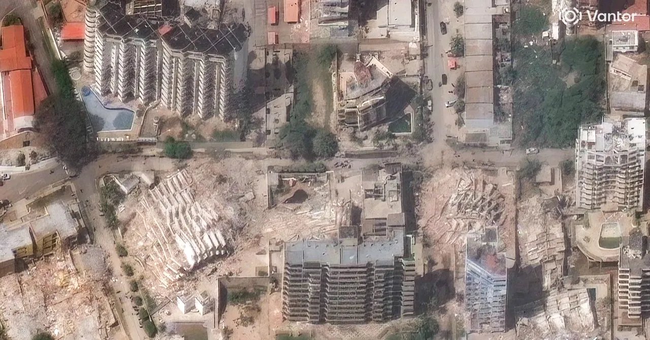
Satellite Technology Is being used to streamline rescue efforts in Venezuela following the two earthquakes that struck on June 24. Space agencies have shared images with emergency authorities and the Venezuelan government that not only reveal the magnitude of the disaster but also allow response teams to identify where to focus their efforts—and the challenges on the ground.

Following the twin earthquakes in Venezuela, the Copernicus satellite system activated its emergency mapping mode at the request of the European Commission’s Directorate-General for Civil Protection and Humanitarian Aid Operations. Using imagery collected by Sentinel satellites and sensors, the system has generated 10 products and 25 maps that enable real-time assessment of the extent of damage and how terrain has shifted in 13 areas of interest. In addition, these tools have helped officials identify clear areas that can be used for landing aircraft involved in rescue operations and the delivery of humanitarian aid.

Initial data from Copernicus shows severe damage in the cities of La Guaira and Greater Caracas, as well as impacts on communities in Aragua, Carabobo, Falcón, and Miranda. The report notes that, as of June 27, an estimated nearly 1,300 buildings have been affected in the region.

Venezuela Copernicus

A satellite map created by the Copernicus system identifies areas severely affected in Venezuela following the earthquakes of June 24, 2026.

Courtesy of Copernicus

For its part, NASA activated its Disaster Response Coordination System to produce a series of maps that show how the earthquakes displaced the Earth’s surface using data obtained by the NISAR mission, “providing key insights for emergency managers and scientists,” according to the agency.

This initiative includes a pilot project aligned with Copernicus’s efforts that, using radar images captured by the Sentinel-1 satellite before and after the earthquakes, assesses the areas previously identified by the European system.

Mapa NASA daños Venezuela terremotos

A NASA satellite map shows ground displacement in the areas of Venezuela devastated by the two earthquakes that occurred on June 24, 2026. Red dots indicate areas with a greater than 75 percent probability of damage.

Courtesy of NASA


Source link

  • Related Posts

    In a bold move, Rocket Lab acquires Iridium Communications

    “Success will come from those who can bring new innovations to space quickly and sustain them over time as efficiently as possible,” Desch said in a statement. “We’re excited about…

    The 2 Best Slushie Machines of 2025 for a Chill Summer

    No and yes. Slushies rely on a helpful property of water: Sugar (and salt) dissolved in water lowers its freezing point below 32 degrees Fahrenheit. Why? Solubles like sugar are…

    Leave a Reply

    Your email address will not be published. Required fields are marked *

    You Missed

    Toronto ticket prices surge for Ronaldo World Cup game as Vancouver’s plummets

    Toronto ticket prices surge for Ronaldo World Cup game as Vancouver’s plummets

    Parcel Bomb Explodes in Monaco, Injuring 3

    Parcel Bomb Explodes in Monaco, Injuring 3

    Opinion: B.C.’s new electricity plan is at odds with its economic ambition

    Opinion: B.C.’s new electricity plan is at odds with its economic ambition

    In a bold move, Rocket Lab acquires Iridium Communications

    In a bold move, Rocket Lab acquires Iridium Communications

    Wardogs cheaters will be easy to deal with, claims CEO

    Wardogs cheaters will be easy to deal with, claims CEO

    Carson Jerema: Mark Carney will be prime minister forever