dailynewsnblog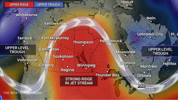

Listen to this article
Estimated 3 minutes
The audio version of this article is generated by AI-based technology. Mispronunciations can occur. We are working with our partners to continually review and improve the results.
Alberta is in the throes of what’s called an “omega block” weather pattern that drives intense heat and severe weather.
Named after its likeness to the Greek letter, the wavy wind pattern squiggled coast-to-coast is trapping much of the Prairies in a pocket of hot air.
Calgary-based weather specialist Kyle Brittain says a jet stream “river of air” moving around the planet can sometimes weaken and buckle to form an omega block. The block creates areas of high and low pressure, blocking normal weather systems.
“It looks like an atmospheric traffic jam,” Brittain told CBC’s Edmonton AM.
Under the ridge currently lies the Canadian Prairies, which is experiencing clear skies and extreme heat.
In Alberta, it means temperatures that are topping 30 C and overnight lows through the mid-to-upper teens. Brittain said those lows are typically what’s considered a normal daytime high for this time of year.
“This is going to be associated with record-breaking heat for probably three more days here in Alberta,” he said Wednesday.
It’s an even hotter picture heading east toward the Saskatchewan border and into Manitoba. According to The Weather Network, Saskatchewan temperatures have already broken records for 2026.
Brittain noted the same pattern is being seen on the other side of the globe, where western Europe is facing a sweltering heat wave.
Thunderstorms are part of this weather phenomenon. Parts of southern and central Alberta were hit with a flashy light show Tuesday night, while much of the province will see storm activity over the next few days.
Brittain said unpredictable thunderstorms will overlap with the heat. Risk of storms across Alberta in the coming afternoons and evenings predict heavy downpours, strong wind gusts and intense lightning.
That rain will cool things down into the weekend. Daytime highs in Edmonton, for example, will drop by 10 degrees between Friday and Sunday.
Brittain said the precipitation and lower temperature will mitigate fire risk following what’s been an otherwise quiet wildfire season, both provincially and nationally, relative to previous years.
But the fire situation could change.
The Weather Network outlook further into the summer looks hot for the Prairies, alongside a developing El Niño. Above average temperatures are expected for B.C. and Alberta, with pockets of drought.
“Hopefully we get our seasonal June monsoon, so to speak, in the coming weeks,” Brittain said.
“If we get a lot of rain as expected in the coming weeks, then we’ll be staving off more wildfire danger, drought and things of that nature.”