Shipping traffic through the Strait of Hormuz remains constrained a week after the United States and Iran said they would facilitate vessel passage under a two-week ceasefire agreement. Instead, tensions have escalated. After Iran said ships must coordinate with its forces — and, in some cases, pay a toll — President Donald Trump called the demands “extortion” and announced Sunday that the United States would block ships entering or exiting Iranian ports, adding pressure to an already fragile truce.
But even as Washington seeks to squeeze Iran economically, Tehran retains a powerful advantage: geography. Over six weeks of conflict, Iran has halted virtually all traffic in the strait by laying mines, according to its military forces, and exploiting the vulnerability created by its terrain. Even under a U.S. blockade, these factors allow Iran to continue exerting influence over who crosses — and at what risk.
That risk, more than any formal closure, is what is keeping ships away. According to data from Kpler, only seven vessels have crossed the strait daily on average since the ceasefire, compared with the prewar traffic of more than 130 ships. “De facto, the ceasefire has done absolutely nothing to change the situation [in the strait]. None whatsoever,” said Lars Jensen of Vespucci Maritime, a container shipping consultancy based in Copenhagen.
Here’s what makes the Strait of Hormuz so critical, and how its geography continues to define the standoff.
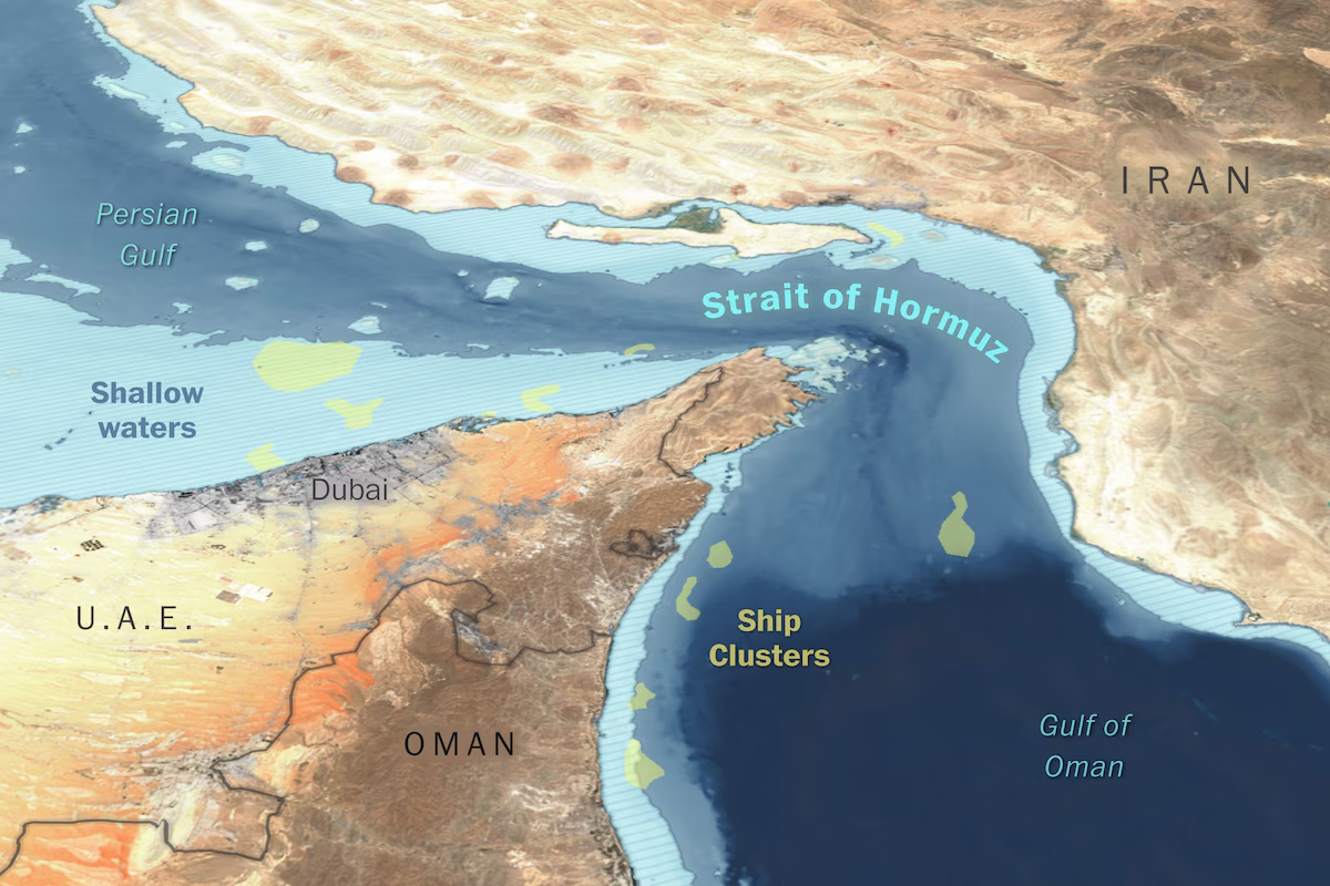
Before the war, the Strait of Hormuz facilitated about 20 percent of global oil flows, roughly 20 million barrels of oil per day, and 20 percent of the global liquefied natural gas trade. It is the only maritime exit from the Persian Gulf, making it a critical choke point.
Key oil refineries dot the coastline of the strait and the Persian Gulf.
The geography of the strait itself makes this energy pipeline vulnerable and easy to disrupt.
Even during peacetime, only a few ships could transit at a time, leading others to queue or anchor nearby, creating clusters of vulnerable targets.
Shallow waters in the strait force ships to be funneled through two narrow lanes (about two miles wide each). This leaves vessels extremely vulnerable to missile and small-boat attacks.
Crews crossing the narrow strait also have to worry about sea mines, which can detonate upon contact or upon sensing movement. “Mines are a psychological issue as much as they are a real issue,” said Frank Galgano, an associate professor of geography and the environment at Villanova University, adding that it would take several weeks to clear mines from the navigation lanes.
Iran’s Islamic Revolutionary Guard Corps said Thursday that vessels transiting the strait must divert around Larak Island, off the country’s coast, with the primary navigation lanes posing a risk because of sea mines. The detour also allows Iran’s military to screen ships and collect tolls for passage.
A rugged coastline offers hiding spots for small attack ships.
The elevated terrain along Iran’s coast provides clear vantage points for surveillance and for launching anti-ship cruise missiles.
The small islands also can be used to launch missiles at ships passing by.
Bandar Abbas, a city at the mouth of the strait, allows Iran to deploy boats and missiles and to monitor or disrupt traffic within minutes.
“All in all, Hormuz’s geography amplifies Iran’s anti-access and area-denial leverage at low cost,” said Basil Germond, a professor of international security at Lancaster University.
These tactics, combined with the fact that the ships crossing the strait are usually massive and travel slowly, make the passage extremely dangerous. Defense experts say the vessels have close to no ability to detect a threat. “The Iranians are literally right on top. So you’ve got an instant almost to react,” Galgano said.
Iran’s ability to threaten ships with low-cost drones and mines has proved a frustration for Trump, who acknowledged last month that such attacks would persist “no matter how badly defeated they are.”
Although no vessel attacks have been recorded since the ceasefire announcement, risk has become the defining force driving the standstill in traffic. Experts say that even when all blockades are lifted, it will take time for traffic to return to prewar levels. “This is very simple: Shipping companies will continue to avoid the strait as long as Tehran maintains its capability to credibly threaten commercial shipping in the strait and the Gulf,” Germond said.
After the U.S. announced its blockade, Iran said it would strike back if its ports were threatened, heightening tensions for shipping companies already hesitant to cross. At the same time, Tehran’s toll system has introduced a new legal risk: Vessels that pay the Revolutionary Guard for safe passage could be seen as violating U.S. or European Union sanctions on Iran, further deterring operators.
With confusion surrounding the status of the strait, shipping operators remain in a wait-and-see mode. According to Windward, more than 700 vessels were still trapped in the Gulf as of Monday.
The shipping giant Hapag-Lloyd said in a Wednesday statement that “the situation around the Strait of Hormuz remains volatile. … Based on our current risk assessment, we are currently refraining from transiting the strait.”
For traffic to return to normal, analysts say, the shipping sector will need to be confident that the ceasefire will hold and that Iran will not attack in-transit vessels. “If you move your ship and you’re halfway through the Hormuz channel and the ceasefire breaks down, well, your seafarers are then in a shooting gallery,” Jensen said. “So you want to see a relatively solid ceasefire before you even trust going in there.”
But that confidence depends on a delicate balance. It is in Iran’s interest to keep restricting passage in the strait, “one of their last remaining leverages in the war,” Germond said in an email. “So long as Tehran is serious about the ceasefire, they must implement (or be seen as implementing) its Hormuz clause and, thus, allow more and more ships to transit. If they still restrict traffic to keep some leverage, this actually risks collapsing the ceasefire altogether. So, for them, this is a thin boundary to navigate.”
About this story
The data for the map was collected from multiple sources: Global Maritime Traffic (previous shipping routes), Sentinel-2 (ship locations, satellite imagery), Kuva Space (ship locations), Mapzen (terrain), NASA (populated areas), General Bathymetric Chart of the Ocean (Bathymetry), and MapStand (refinery locations).
Reporting by Júlia Ledur and Dylan Moriarty. Editing by Emily M. Eng and Maureen Linke. Copy editing by Shibani Shah.