Listen to this article
Estimated 5 minutes
The audio version of this article is generated by AI-based technology. Mispronunciations can occur. We are working with our partners to continually review and improve the results.
An evacuation order has been issued for part of a hamlet near Bella Bella, B.C., as heavy rain pummels much of the province’s central and south coast.
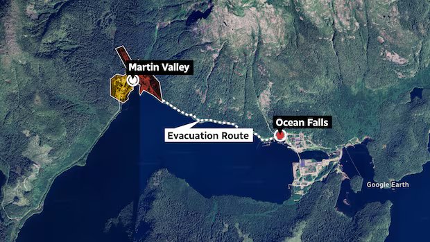
Residents in part of Martin Valley, located in the Central Coast Regional District’s Electoral Area A, have been ordered to leave immediately.
The regional district issued a state of local emergency on Tuesday, saying “the landslide and flood hazard risk is a significant threat to the health, safety and welfare of persons.”
On Wednesday night, an evacuation order was also issued for portions of the nearby Ocean Falls area.

Martin Valley is located about 35 kilometres northeast of Bella Bella, as the crow flies.
Evacuees have been told to follow the evacuation route provided, close all doors and windows, gather family and neighbours, if possible, and take critical items such as medicine, wallets and insurance policy contacts, if immediately available.
Evacuees can request and register for support at Old Bank Inn in Ocean Falls.
An evacuation alert is also in place for a separate area of the hamlet, due to the “current flooding and potential landslide risk from Mt. Caro Marion above village of Martin Valley,” according to EmergencyInfoBC.
An evacuation alert requires affected residents to be ready to leave on short notice.

Steve Emery, the director for the regional district’s Electoral Area A, said earlier Wednesday that water from the heavy rains has flooded a few roads and basements of homes, but noted there hasn’t been a landslide.
He said a majority of residents under evacuation order have decided to remain in their homes and noted people living in the Ocean Falls area understand the dangers of living in a “slide zone.”

Emery said he hopes the provincial government will follow up on making sure the local highways are properly maintained by contractors.
“The highways department kind of forgets about us in the middle of nowhere,” he said. “We’re probably the most remote highway system in all B.C. for access and the number of people living [here], so it makes it challenging.”
A statement from the regional district noted that the area above Martin Valley had a documented history of landslides, including a 1965 landslide that resulted in six deaths.
Flood watch
The province’s River Forecast Centre had issued a flood watch for the Central Coast, meaning there could be flooding of areas adjacent to riverbanks.
However, that was downgraded later on Wednesday afternoon to a high streamflow advisory, with the forecast centre saying precipitation rates were slowing.
Parts of the Central Coast are also under a rainfall warning, south of Bella Bella near Rivers Inlet, according to Environment Canada.
The agency said between 150 and 200 millimetres of precipitation is expected for coastal communities, and up to 250 mm is forecast over the mountains “except locally higher amounts approaching 300 mm.”
Rain continues on South Coast
Heavy rain also continues to fall further south.
Environment Canada says a “prolonged atmospheric river event” will bring precipitation to northern areas of Metro Vancouver and Howe Sound, the Fraser Valley, and inland and western Vancouver Island.

Environment Canada has issued rainfall warnings for several areas of B.C.’s coast amid a prolonged atmospheric river event. CBC’s Johanna Wagstaffe visited Lynn Creek where river surges are hitting the shoreline in strong waves.
The agency is warning that extensive water pooling on roads is possible and there is an enhanced risk of landslides.
“The heaviest rainfall is expected Thursday night into Friday morning,” according to the warning.

It’s a term that became more widely known after record-setting flooding hit B.C. in November 2021, but as meteorologist Johanna Wagstaffe explains, atmospheric rivers are not new to west coast of North America.
A flood watch was issued on Wednesday afternoon for the Fraser Valley, the Howe Sound, Sunshine Coast and Metro Vancouver’s North Shore.
The River Forecast Centre said that snowmelt is expected to contribute to swollen river levels, and up to 150 mm of rain could fall on the South Coast from Wednesday until Friday.
“The earlier phase of the storm deposited a substantial amount of mountain snowpack. Fresh snow is more susceptible to melting than older, established snowpack,” the warning reads.
Environment Canada has urged caution for drivers, noting localized flooding in some areas is likely and some roads may become impassable.
“Landslides may occur in vulnerable areas such as steep slopes, deforested areas or recent burn scars.”
High streamflow advisories, which mean river levels are rising but no major flooding is expected, have been issued for Vancouver Island, the Fraser Valley, the South Coast and North Coast, and the upper Fraser region, including the Robson Valley and tributaries near Prince George.